How to Start a 50 States Postcard-Geography Album Project
 |
| Postcards we received from Montana. |
How To Begin
You should start your project with a handful of postcards from various states so that you can begin your studies and projects and post about them. With each post, include a request for additional postcards from your readers. Be specific about what postcards you are looking for and what you expect from your donors. For example, if you are willing to send a postcard from your state, you should say that. You may get your initial stock of postcards from various sources. Do you have friends, co-workers or relatives in other states that you can ask to send you a postcard? You can also post on your blog that you will begin a postcard geography project in a few weeks and that you are seeking some postcards to begin the project. You can also join a postcard exchange group such as Postcrossing. Be aware, however, that you never know what you will receive. Some postcards will be artistic or just patterns. You might also receive a number of postcards from the same area. They do the best they can with varying the matches, but the down side to this is that the results will be very variable as well. The personal touch is, of course, always better. Once you begin posting on your blog the wonderful things you are doing with your state studies, you may get people offering to send you postcards from their state in your comments. Make sure you are prepared to give an address to them. If you are uncomfortable in giving your street address out, you might want to get a Post Office Box just for this purpose. Also, be sure to ask if they have a blog of their own that you can link to. You may begin your 50-State study even while you are waiting for the postcards to come in. Start with your own state! Pick up some postcards to add to your album, perhaps go on a field trip and begin!
 |
| Sometimes you will get a whole surprise package instead of just postcards, like this package we were sent as part of our study of Louisiana. |
Now that you have a supply of postcards, what next?
 |
| Our North Carolina page in our Postcard-Geography Album. |
The Postcard Itself
We always like to find as closely as we can where the postcard came from. Look for the city on the postmark. What did the sender say on the postcard about their state? What picture(s) are on the postcard? What about the stamp? These things might lead to further investigations.
Books, Books, Books
Next we like to get books out on the state. Sometimes these are factual books and sometimes these are fictional books set in the state. You can learn much from both kinds of books about the state and the people who live there.
 |
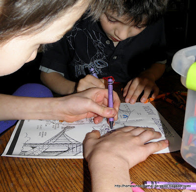
| James and Quentin had a good time coloring the state coloring page of New Jersey together. |
The State's Borders
Look at the state in terms of what surrounds it. Other states? What are they? What bodies of water surround it? What other natural features form the states' borders? Sometimes state borders were determined by a river or a mountain range. You can make or color a map of the state and put these features in.
 |
| History Pocket pages that we made in conjunction with our study of Arizona. |
History of the State
When did the state enter the Union? Put this on a timeline? What was happening at the time? Who was president? What political issues were involved with the state?
 |
| Geography terms pop-up we made while studying Nevada. |
Natural Resources and Features
What natural resources does the state have? What products does it export? What other natural features (besides the ones that form it's borders) does the state have? Can you figure out the climate of the state from its natural features? How does this flavor the character of the state? How does it influence the people who live there?
The State Motto, Bird, Tree, etc.
What the state has determined represents them says a lot about the state. If you haven't been able to determine the state's climate from its natural features, perhaps the state tree, flower or bird can give you further clues. Learn about them. Color pictures of them. Sometimes you will need to research further to determine how the state got their motto.
 |
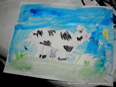
| Cow art project we did with our state of Wyoming study. |
A Hands-On Project
Some families like to complete a hands-on project related to the state. If my boys can't remember a state, usually all I have to do is mention the project we did in conjunction with the state and they remember everything they learned about the state, even things unrelated to the hands-on project itself. It seems, for them, the project is the centerpiece in which they can hang all the other facts onto.
 |
| One of the science experiments we did to explain why the Statue of Liberty is it's famous green color when we studied the state of New York. |
Often we will get an idea for a project while we are doing the above research. Sometimes it will be an art project, sometimes a science project, and sometimes a history project. We like to vary the projects so it doesn't get stale.
 |
| A meal of Maryland fried chicken, Smith Island spoonbread, cucumbers, tomatoes and onions and watermelon to celebrate our Maryland State study. |
Make a dish or a Meal from the State
Once I get an offer for someone to send me a postcard, and I give them the address I want them to send it to, I often ask Them what dish, beverage, snack or desert they feel would represent their state. I find this to often be better than trying to find out this information from other sources (such as books or the internet) but be aware that the suggestion might be regional to the area of the state from which they come, and not necessarily from the state at large. Some people like to do the same thing for each state, a dessert from each state for example, or a whole meal. In this way comparisons are easier to make. I like to vary it, however, according to our wants and needs for that week or that state. For example, if we have already completed a complicated art project, we might want to do something simple, but if no other projects come to us, we might want to do a complete meal including dessert. Likewise, if we have a very busy week, we might keep it more simple than if we have a light week in our other obligations.
 |
| An assortment of maps and brochures we received for our study of Maine. |
Making a 50-States Postcard Album
We decided that a simple scrapbook album gave us enough room to include everything we wanted and yet was flexible enough to accommodate the varying projects we completed. If we made something 3-dimensional, (our meals, for example) we snapped a photo of it and included that on the page. We included a variety of things, depending on what we came across and what interested us. We have included recipes, brochures, pamphlets, lapbook pieces, maps, paper dolls, art projects, photographs, narrations, reports, articles from newspapers or magazines and sketches. State quarters are also a great thing to add and a resource for jumping off places for state studies. I am sure that you could come up with other things, too!
For our first page, I printed out a map of the United States so that each state, as we studied it, could be colored in. This helped with some of the explorations regarding state borders, but also helped them see the progression of their studies. They sometimes made observations such as states from a region were similar to each other. A regional map was completed by my older students for this purpose.
One of the nicest aspects of making a Postcard-Geography album is that it can be a multi-age project and an on-going project. You can keep adding to it as your students get older, learn more, go on more field trips, etc. It is a constantly changing work-in-progress that they love looking back on and reminiscing.
My Favorite States Resources:
American Grub - Eats for Kids from All Fifty States, Lynn Kuntz
Discover America, State by State, Alphabet series
Our 50 States: A Family Adventure Across America, Lynne Cheney
Our 50 States: A Family Adventure Across America, Lynne Cheney
Most of our map coloring pages were from United States Coloring Book.
List of State Foods
Letterboxing opportunities, listed by state
50 States.com has, among other things, state nicknames
Coloring Castle for State Coloring Pages
Postcrossing for postcards
Crayola for state coloring pages
Kidzone Geography for state printables
Know Your State geography practice
H.I.P. Pocket Change for 50 State Quarters program
Stone Soup for an example of a state notebook
Graphic for posts that shows how many states you have completed can be found here at Douwe Osinga's Project and epg soft
Large maps to print out (as large as 8 pages (64 sheets of paper; over six feet across!) at Owl and MouseList of State Foods
Letterboxing opportunities, listed by state


